Prior to the Hurricane Harvey, it was surprising to learn how many residents did not know they lived behind a levee or did not know the ways to contact the entities responsible for owning and operating the systems. Although existing residents are now more familiar, the issue still remains for new and potential home owners. This page mainly focuses on locating levees in Fort Bend County; however, it includes national resources for levees across the Country.
Local Search Options
Fort Bend County Levee Interactive Map
The Fort Bend County Drainage District has developed an interactive map that shows the various levee systems and District Contacts (click on the image below).

As shown on the above image, the Drainage District has included an address search. To locate whether or not your home or potential home is behind a levee, enter your address and the site will zoom to the location. Once at a known location, you can click on the levee system and the window will give you the names of the District’s contacts and the District’s website. For a list of the Fort Bend County Levee Systems and associated website resources see our Fort Bend County Levee Links page.
Fort Bend Central Appraisal District
The Drainage District interactive map is the easiest way to determine whether a property is within a levee system. Since every levee owner is a taxing entity, the Fort Bend Central Appraisal District is another local source that not only show the name of the levee owner, but also give you the current tax rate of the District. To get started, enter an address into the search feature near the top half of the site (see image below).
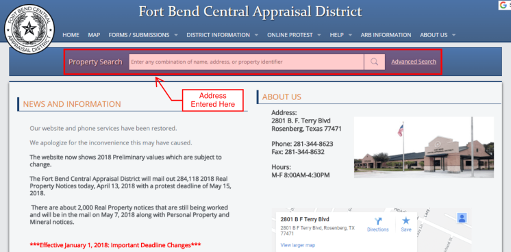
Once the search is complete, you will see a list of the taxing entities and their associated tax rates.
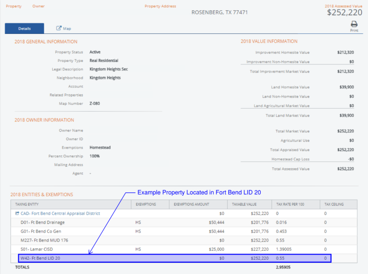
If you list includes any of the following entities, the property is within that levee related district.

National Search Options
FEMA Map Service Center
All accredited levees in Fort Bend County as well as other areas across the country are mapped with a special note showing that an area is “protected from the 1-percent-annual-chance or greater flood hazard by a levee system.” If using the Map Service Center, start by following the process as described at Are you in a Floodplain?. Once your search is complete, if the property is within the area protected by a levee, the dynamic map should have the color hatching similar to the example below.


USACE National Levee Database
In 2007, in the aftermath of Hurricane Katrina, Congress authorized the United States Army Corp of Engineers (USACE) to develop the National Levee Database of levee systems in the United States. Based on the description, “the database contains information to facilitate and link activities, such as flood risk communication, levee system evaluation for the National Flood Insurance Program (NFIP), levee system inspections, flood plain management, and risk assessments. The NLD continues to be a dynamic database with ongoing efforts to add levee data from federal agencies, states, and tribes.” The database is still a work in progress. It includes federal systems, but the USACE is still working on adding non-federal systems to the database.

The database includes a few ways of searching for systems including a map and zip code search. We have had better luck using the map search. Below are is a screenshot of the Fort Bend County levee systems currently included in the database.
